Map Config
Map Style
Map style config is used to apply custom map styles on a user, company, and team level.
Order of Preference
Map styles can be defined on the user, company, and team level.
A high order of preference will override lower order of preferences. For example, a team style will override a user style definition.
Definition
Element Type
The properties of the config object represent the element type in which the styles are applied. This will be an array of style definitions
polygon: option definitionpolyline: option definition
The style definitions at the top of a list will have highest preference!
Style Definition
item: which type of items to apply this style to.projectorassetname: a user friendly name for a description of this styleselector: used to determine which items to apply this stylestyle: definition of style to apply
Selector
The process to select a specific style to apply is as follows
- Discard if
active: false - Discard if
name: <name>and name is not included in element name - Keep if
drawing: trueand it is a drawing element - Attempt to grab
item: project || asset, discard if doesnt exist - Discard if
bindPath: <bp>andbpis not bind path of element - Keep if none of the following selectors
exists,get, orvalue - Return check for undefined of
existsparameter path - Get value of
getpath and return check for equality withvalue
Examples
Color polygons of rated parcels
polygon:
  - item: asset
    name: Highest Rating
    selector:
      get: step.land.asset.land
      property: rating
      value: 3
    style:
      fillColor: '#d2e5b8'
      fillOpacity: 0.3
      strokeColor: '#9fc866'
      strokeOpacity: 0.95
      strokeWeight: 3
  - item: asset
    name: Middle Rating
    selector:
      get: step.land.asset.land
      property: rating
      value: 2
    style:
      fillColor: '#f7d1aa'
      fillOpacity: 0.3
      strokeColor: '#ee9b48'
      strokeOpacity: 0.95
      strokeWeight: 3
  - item: asset
    name: Lowest Rating
    selector:
      get: step.land.asset.land
      property: rating
      value: 1
    style:
      fillColor: '#e4b1b3'
      fillOpacity: 0.3
      strokeColor: '#c5575b'
      strokeOpacity: 0.95
      strokeWeight: 3
Color project search radius and completed projects differently
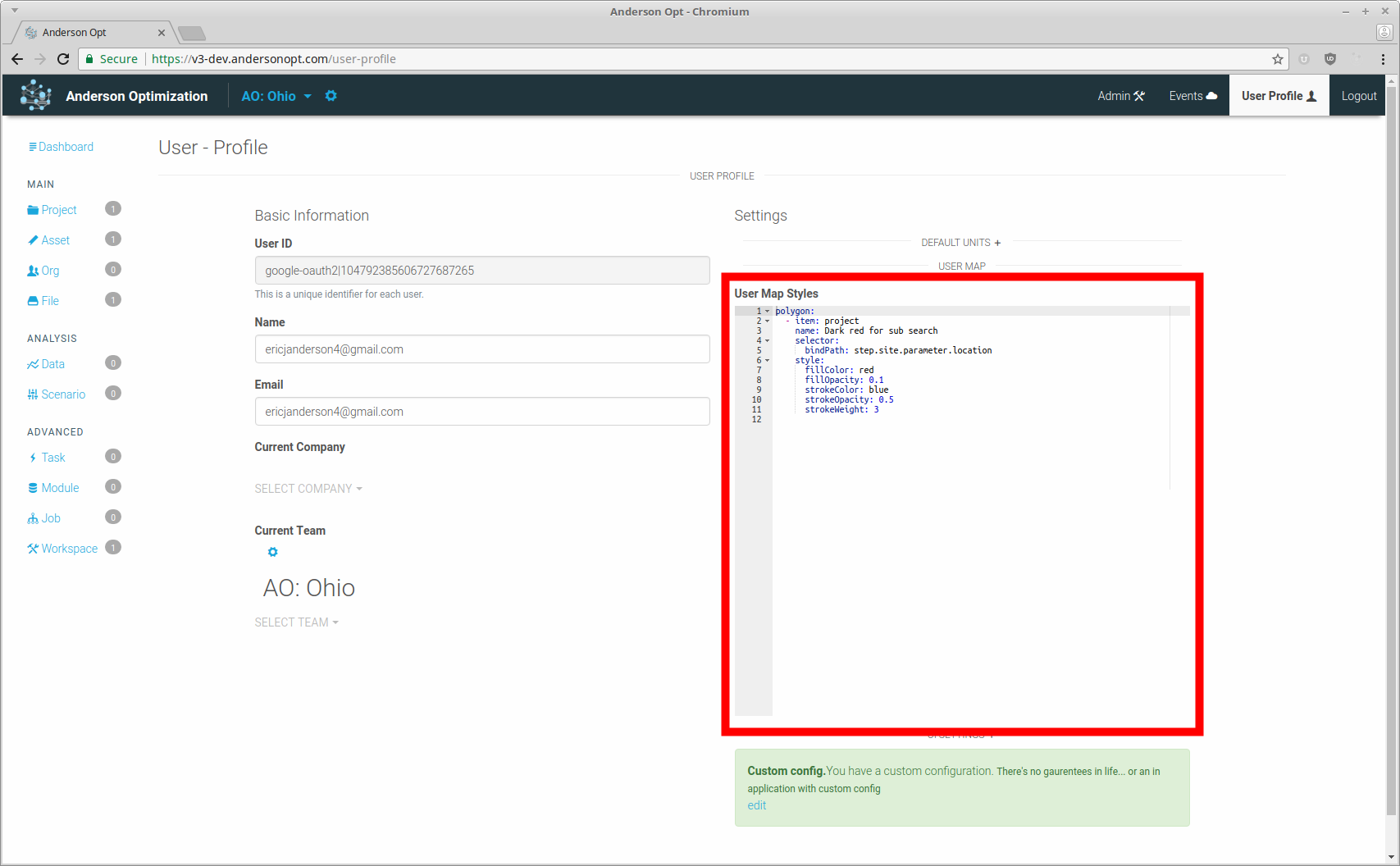
polygon:
  - item: project
    name: Dark red for sub search
    selector:
      bindPath: step.subs.parameter.search
    style:
      fillColor: red
      fillOpacity: 0.1
      strokeColor: red
      strokeOpacity: 0.5
      strokeWeight: 2
  - item: project
    name: Is completed
    selector:
      bindPath: step.subs.parameter.search
      get: step.start.parameter.project.completed
      value: true
    style:
      fillColor: red
      fillOpacity: 0.05
      strokeColor: blue
      strokeOpacity: 1
      strokeWeight: 5
polyline:
  - item: project
    name: Is completed
    selector:
      get: step.start.parameter.project.completed
      value: true
    style:
      strokeColor: red
      strokeWeight: 5
  - item: asset
    name: User Loaded Lines
    selector:
      bindPath: parameter.location
      get: meta.loadGroup
      value: UserLine
    style:
      strokeColor: blue
Enhanced power flow data
- Use a different marker for power flow data set
- User a different color for transmission lines
- Change transmission line color based on capacity
marker:
  - item: asset
    name: EV Substations
    selector:
      bindPath: parameter.location
      get: meta.source
      value: EV
    style:
      url: >-
        https://static.andersonopt.io/map-icons/asset-network-substation-EV-V1.png
polyline:
  - item: asset
    name: EV Substations
    selector:
      bindPath: parameter.location
      get: meta.source
      value: EV
    style:
      strokeColor: blue
  - item: asset
    name: EV Substations
    selector:
      bindPath: parameter.location
      get: parameter.transmission.s_nom_A
      min: 750
    style:
      strokeColor: red
      strokeOpacity: 1
  - item: asset
    name: EV Substations
    selector:
      bindPath: parameter.location
      get: parameter.transmission.s_nom_A
      max: 750
      min: 250
    style:
      strokeColor: '#9FC866'
      strokeOpacity: 1
  - item: asset
    name: EV Substations
    selector:
      bindPath: parameter.location
      get: parameter.transmission.s_nom_A
      max: 250
      min: 100
    style:
      strokeColor: '#B9D68F'
      strokeOpacity: 1
  - item: asset
    name: EV Substations
    selector:
      bindPath: parameter.location
      get: parameter.transmission.s_nom_A
      max: 100
    style:
      strokeColor: '#D2E5B8'
      strokeOpacity: 1
Marker example
This example will attempt to style unstyled marker with the follow
- All markers with googles standard pin drop
- All elements with name tree with a pin drop with letter T
- All elements with name frog with a pin drop letter F
The letters will override the default styling.
The drawing selector will only allow drawing elements to be styled.
marker:
  - selector:
      drawing: true
    style:
      height: 30
      url: >-
        https://mt.google.com/vt/icon/text=&psize=16&font=fonts/arialuni_t.ttf&color=ff330000&name=icons/spotlight/spotlight-waypoint-b.png&ax=44&ay=48&scale=1
      width: 30
  - selector:
      drawing: true
      name: Tree
    style:
      height: 50
      url: >-
        https://mt.google.com/vt/icon/text=T&psize=16&font=fonts/arialuni_t.ttf&color=ff330000&name=icons/spotlight/spotlight-waypoint-b.png&ax=44&ay=48&scale=1
      width: 50
  - selector:
      drawing: true
      name: Frog
    style:
      height: 10
      url: >-
        https://mt.google.com/vt/icon/text=F&psize=16&font=fonts/arialuni_t.ttf&color=ff330000&name=icons/spotlight/spotlight-waypoint-b.png&ax=44&ay=48&scale=1
      width: 10
Admin settings
Map style config
polygon:
  - item: asset
    name: Highest Rating
    selector:
      get: step.land.asset.land
      property: rating
      value: 3
    style:
      fillColor: green
      fillOpacity: 0.4
      strokeColor: lawngreen
      strokeOpacity: 1
      strokeWeight: 4
  - item: asset
    name: Middle Rating
    selector:
      get: step.land.asset.land
      property: rating
      value: 2
    style:
      fillColor: yellow
      fillOpacity: 0.3
      strokeColor: yellow
      strokeOpacity: 1
      strokeWeight: 3
  - item: asset
    name: Lowest Rating
    selector:
      get: step.land.asset.land
      property: rating
      value: 1
    style:
      fillColor: red
      fillOpacity: 0.3
      strokeColor: red
      strokeOpacity: 1
      strokeWeight: 3
polyline:
  - active: false
    item: asset
    name: Has voltage
    selector:
      exists: parameter.transmission.voltage
    style:
      strokeColor: blue
      strokeWeight: 3
Map Layers
Examples
Admin settings
layers:
  energyinfrastructure:
    name: Energy Infrastructure
    show: false
    tags:
      - energy
      - name: north america
        type: region
    type: arclayer
    url: >-
      https://geoappext.nrcan.gc.ca/arcgis/rest/services/NACEI/energy_infrastructure_of_north_america_en/MapServer
  nfhl: true
  opentopomap: true
  reportall:
    name: Parcels
    query: 'https://reportallusa.com/api/parcels.php?client=SEOKOgAyW4&v=2'
    show: false
    tags:
      - parcels
      - name: united states
        type: region
    type: parcellayer
    url: >-
      https://reportallusa.com/dyn/tile.py?map=siteroot/Base_Layers.map&layer=Parcels&mode=tile&tilemode=gmap&tile={x}+{y}+{zoom}&client=SEOKOgAyW4
  resourcepotential:
    name: Solar Resource Potential
    show: false
    tags:
      - solar
      - resource
      - name: north america
        type: region
    type: arclayer
    url: >-
      https://geoappext.nrcan.gc.ca/arcgis/rest/services/NACEI/energy_resource_potential_of_north_america_en/MapServer
  usenergy:
    name: US Energy Mapper
    show: false
    tags:
      - energy
      - name: united states
        type: region
    type: arclayer
    url: >-
      https://maps.eia.gov/arcgis/rest/services/USEnergyMappingSystem/20190205/MapServer/
    visible: '132,33,131'
  usgstopotile:
    name: USGS Topo - National Basemap
    show: false
    tags:
      - basemap
      - name: united states
        type: region
    type: tilelayer
    url: >-
      https://basemap.nationalmap.gov/arcgis/rest/services/USGSTopo/MapServer/tile/{zoom}/{y}/{x}
  wetlands: true